Hello everyone. It’s been a bit but I’m back with a new installment of the updated Realms Map and I even feel like I’m headed into the final stages of completion of this project. Yes, there is still a lot to do, but most of the largest parts of the map are finished. The great majority of what remains are smaller details that each will take a lot of individual attention and time. So while we can’t look at the finished project just yet, looking at the current map can certainly give you the feel of what it will look like when it is finished.

So without further preamble, here is a link to the current state of the map: https://www.realmsnet.net/maps
Complete nations that have been added since the last update are: Creathorne, Ivory, Ekembria, Iron Kingdom, and Saurabia.
There’s much more to see than just the added nations, however. First, I should explain a convention that I have adopted as I’ve put this all together.
When zoomed out all the way (as seen in the image above) the most obvious thing on the map are the nations with political borders. That’s also the thing that has most cluttered the previous versions of the map in the past. So I’ve made a decision to help keep that clearer in the future. Areas with colored political borders are either:
Active character-made nations with members that currently play.
Character-made nations that are historic and may not have members that currently play, but are being actively used by plot-holders to throw content.
There are many areas of the map that have great detail to them that do not fit those very narrow criteria. Thus you will find areas like Corisca or Mythguard, places that have a history and population centers and points of interest on the map, but do not have political borders. These areas are labled with middle-level-zoom labels and have lots of high-level-zoom details. They just aren't part of the zoomed-out feature which just political-bordered.
Similarly you will see The Southern Wastes, which is the name applied to the entire area of badlands to the south. There are lots of locations within the Southern Wastes but it itself does not have a political border. So the label for the Wastes appears at the middle-zoom level and all of the cities and such are at the high zoom level.
This political border convention described above should help keep the map uncluttered at the zoomed-out level and make it easier for viewers to find what they are looking for. Of course, nothing is set in stone and I’m sure there will need to be some flexibility with this policy, but so far it seems like it will work.
So that's the current state of the map, there's still much to go but I think the end is in sight.
Now I’d like to appeal to the rest of the community to help me make some decisions regarding the future development of the map.
First: when has this map become complete enough that we should ask Ian to replace the link on the main RealmsNET page to direct to this map rather than the historic one? I think maybe we’re close but I won’t argue if people think this map should be 100% finished before it is linked.
Second: scale. A few months back I introduced the topic of scale in regards to the topographical elevation on the map and how high the heights should be. The general opinion at that time was that things should stay New-England-ish in overall height.
Now I’d like to discuss land-size scale. This is a bit of a tougher nut to crack (apparently).
The convention I think many of us have understood in the past was that the map was supposed to represent a fantasy version of New England. If you look at the historical versions of the map, it’s obvious the coastline of New England, somewhat modified over the years, has been traced.
 |
| Remissil started it all out by turning New England into an island. |
 |
| Carrie expanded the size of the landmass, making the whole shoreline of the Northeast show. |

When I started my map in the early 2000s I copied and was working off of an image of New England that I downloaded. I essentially recreated the map image off of a New England map.
I’m pretty sure that I was the first one to ever add a mileage scale onto the map. This was not part of my initial mapping but it seems like around halfway through my tenure as the cartographer, I added the ruler onto the map key that you can see right above the map title.

Having attempted to reproduce where I got this scale it seems like I copied and pasted the ruler from whatever real-world map I used to get the profile of the coastline to build my old map off of. On that old map and scale, Rhiassa measures a little less than 15 miles across at its widest east-west measurement. I superimposed the scale over where Rhiassa was to get that measurement.

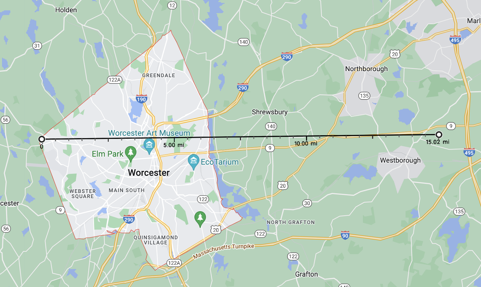
To help improve understanding, 15 miles is roughly the distance between the west edge of Worcester and 495. So far, to me, that checks out. I've always assumed that Rhiassa, a smaller nation compared to many, would be around this size.
Again, to further add information to my own exploration of Rhiassa, Steve Johnson (Rhiassa's founder) always maintained that the capital city, Cold Springs, was meant to be a somewhat typical walled medieval city. I decided to compare it to the size of York, England’s medieval walls, since that’s a very famous example. I found a good-enough map showing those.

The scale on the bottom of that map goes to 1000 feet, so the overall width of the city at its widest point is just about 4/5 of a mile. If I was to represent that on the Worcester map it would look like this:
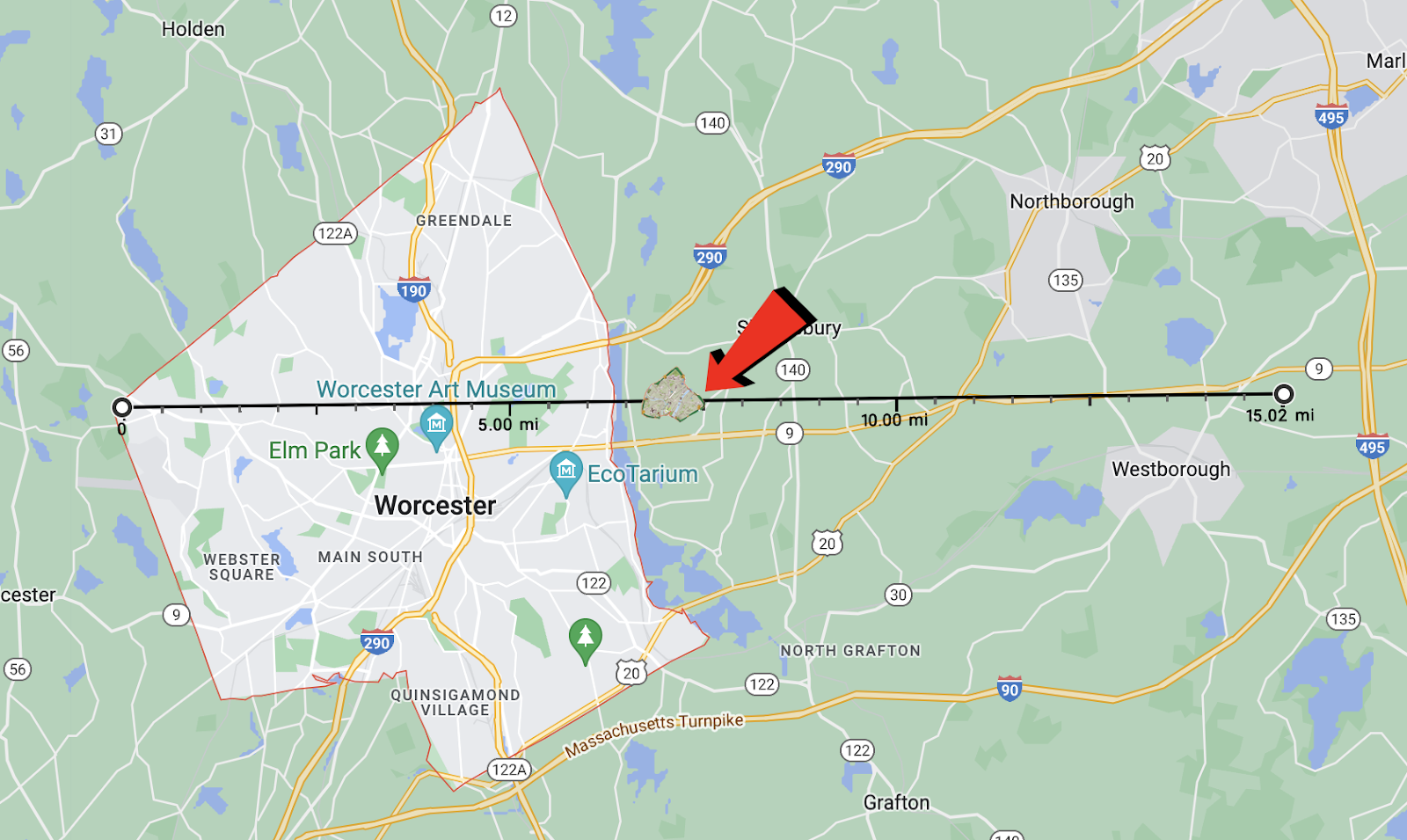
Every two graduations on that ruler is one mile, so that city size there is more or less to scale.
Comparing that to Rhiassa on the current map:

Rhiassa is one of the smaller nations on the map (this exercise only includes Rhiassa proper and not the added provinces of Periden and Lionsmark), so you can extrapolate from there how much larger the other, larger, nations would be on this 1:1 scale. So to me all of that pretty much checks out and the 1:1 scale that I've always internalized seems consistent with how the map is read.
There is also an argument for officially deviating from that 1:1 scale to expand to something bigger. Here to make that argument in 1500 words or less is Pat Bobell:
-----------------------------
A Scale for Our Pastime
I recognize that many people might not care about making the Realms world coherent within the medieval fantasy context. I'll warn you upfront that my whole agenda here is to argue that setting the Realms map's scale to match New England's IRL geography is ridiculous, even accounting for plenty of "iT's fAnTaSy" handwaving. Instead, we should use a larger scale to match the visions of the world we have collectively built through our decades of events, stories, and imaginings. To be clear, I think it's extremely cool that the Realms map roughly matches the geography of New England. The first time someone pointed that out to newbie-from-the-midwest me, it blew my mind. I want to keep that just the way it is. I don't think things should move around at all. I just want to talk about the distances between them. Since before I started playing in 2010, the Realms map we've considered "official" didn't list a scale with which to measure distances between our cities or along our borders. It's not something that ever comes up unless we feel like digging into the details of how long it takes to travel somewhere to add flavor to roleplaying conversation. Or if we wonder how many people live in our nations, or cities, or towns and might be affected by some new threat. Or how large our nations' armies are to fight that threat. Because I like details and figuring things out, and because I view the Realms as being somewhat larger than life (again, medieval fantasy), I was never under the impression that the Realms map distances matched IRL map distances. If we were operating at that scale, the capital city of Rhiassa would have a population three quarters the size of my rural-Illinois high school student body. (Cold Springs would house roughly 870 people, based on my overly-generous estimate.) "But Pat," you might masochistically or indulgently enquire, "how did you arrive at that weirdly specific rough estimate?" The short answer is "I google until I find useful info that seems relevant and decently informed, and extrapolate from that." The next paragraph is the longer answer, with links. Feel free to skip it if you don't care about such details. First, I overlaid a slightly-transparent screenshot of Jason Rosa's new Realms map on a Google Maps screenshot of New England in Inkscape, matching the size and position of Teng Hua up through Rathkeale up with the size and position of the Cape. Next, I pulled ruler lines to the edges of the "20 mile" scale marker on the Google Maps image, and used those lines' coordinates in the program to calculate a conversion ratio between pixels in the image and distance on the 1:1 scale map. After pulling grid lines over to approximate Rhiassa's area as a rectangle (eyeballing the little piece in the southwest fitting into the gaps along the northern border and southeast), I used those lines' positions and the conversion ratio to calculate an approximate land area for Rhiassa as a rectangle. (8.62 miles north to south, 16.83 miles east to west, giving them 145 square miles of area.) Generously assuming a population density of 120 people per square mile, that gives us 17,400 Rhiassans. That 120/sq. mile figure comes from this source, which offers adjustments to one of the most common sources used for medieval fantasy worldbuilding, found here. The revising source pegs 1450s-1500s Belgium at 110-127 people per square mile, one of the highest medieval population densities and according to them, the only European country to go above 100/sq. mile. While a range around 60-80/sq. mile would be more historically realistic, I use 120/sq. mile, the rough peak of historical medieval population density, as a baseline for areas in the Realms that are almost entirely farmable. My reasoning is that this adjustment should account for magic and other "unrealistic" perks of living in our semi-idealized world. From here, we're admittedly on shakier territory as I make some significant adjustments to the methodology offered in "Notes on Medieval Population Geography" to account for the Realms' access to magic and accelerated technological development. The author estimates roughly 5% of the medieval European population lived in cities of population 10,000 or higher, 4.4% in towns of 5,000-10,000 people, 3.5% in villages of 1,000-5,000, 3.1% in hamlets of 100-1,000 people, and the remaining 84% in communities of under 100 people. However, those percentages are for all of 1300s Europe. If we gave Rhiassa at 1:1 IRL scale a city of 10,000 people, that'd be 57% of the entire nation's population in one spot. Technically possible with a lot of magic, but also absurd enough to be beyond reasonable suspension of disbelief. So to adjust these estimates for populations too small for one or more settlements within a size category, I make a settlement with the corresponding percentage of the population. Thus, the largest town in Rhiassa would be 5% of its total population, or 870 people. Of course, a lot of this estimating can be shifted around a little to make things feel better, but we have to start somewhere. So, that brings us back to the capital of Rhiassa. I asked Jason Rosa what Cold Springs looked like in his imagination. He suggested medieval York or Cearcsiconne. I'd never heard of Cearcsiconne before and couldn't find useful numbers for it, but the York Museums Trust estimates that York's pre-Black Death population was around 15,000 people, and after the Black Death it could have dropped to around 10,000 people. Both are obviously drastically different from the 870 people I mentioned before, and this is why: If Rhiassa's total population sat at 17,400 and their capital city held 10k-15k people, that doesn't leave many farmers or other folk to work the other 99% of the countryside. If we're going to be using all the land as a way to estimate how many people there are, we need to be distributing people across that land. The numbers for Chimeron at a 1:1 scale with New England are similar. Chimeron City, the biggest monument to civilization, magic, and civic ego in the game, would have a population of 2,850 people. That's fewer people than modern-day Berlin, MA, the town that Camelot Practice is in that's almost entirely woods and fields and one big pond. Chim City would have barely enough people for a mid-sized village. It just doesn't work with the genre of epic fantasy that we as players and marshals have written for ourselves and each other So here's my suggestion: the scale of our Realms map relative to New England should be 2:1. This bumps Rhiassa's capital city up to a respectable 3500 people and Chimeron City to 14,700*. Those are still a bit smaller than I think most of us would envision if we put some thought into the matter, but anyone who wants to define this stuff for their own lands can adjust percentages and population densities so suit their needs. I'm certainly not telling anyone how to envision their own lands and populations. I just think that a default assumption of matching New England's scale is out of whack with what we already have in our minds, and picking a map scale closer to the scale of our stories will help those of us who do enjoy this kind of worldbuilding and detail to tell coherent stories together. If you read all this, thank you for taking the time. I started work on tracking Chimeron's demographics and population distribution back in 2013 and as you can tell, I both enjoy it and have Opinions. :) If you'd like to get into the weeds on any of this stuff regarding your own lands, or have questions about what I do with Chimeron, feel free to bring it up in person or to DM me on Discord! *The math I'm doing for Chimeronian populations is more complicated than simply multiplying by 4 (which works for my estimate for Rhiassa), because I'm also modeling Chimeron's recovery since the Bedlam War and reclamation of land that was left decultivated in Bedlam's wake. Having a larger population to work with earlier in the process means more land gets reclaimed sooner, which enables quicker/compounding population growth as new infrastructure is built.
-----------------------------
So there's a lot of math to convince you that a 2:1 scale makes more sense historically than a 1:1 scale.
I said from the beginning that I had always meant this to be a community project, so I'm not comfortable unilaterally making any kind of decision about what the scale is regardless of my personal opinion on the situation. The way I see it, the obvious options are 1:1, 2:1, or leave off the scale entirely and let people pretend whatever they want to pretend regardless of mathematical acuity. I extend all of those to you as options and welcome your discussion.