Showing posts with label Maps. Show all posts

Friday, March 15, 2024

Aeston's Cartography Corner Part 6 - Falling Into Place

Wow it's actually been a couple years since we've done one of these map updates! Time sure flies. Happily, however, I have some additions that I am very excited to share with all of you in our continuing quest to maintain this shared visual of our world.

Link to map on RealmsNET: https://www.realmsnet.net/maps


In the last couple months we've finally been able to make our largest single addition to the map to date, the Kingdom of Invictus, which, for those of you with a long historical perspective, will notice takes up the real estate that once was boasted by the Borderlands. 

Invictus has some pretty interesting geographic features worth a closer look. For example here is the capital area of the nation showing how the city of Invictus is set in the shadow of the majestic Cedar Mountain. Across The Acheron, perched upon its tranquil shores is the famous Alchimia Lupinaar.


In the eastern region of the kingdom lies the imposing and odoriferous Great Cinnabog, the largest known swamp in the Realms. Unable to support the infrastructure of roads, travel across this area is accomplished by boat through its many waterways.


There's lots more to see in this expansive nation so make sure you take a look at the link on RealmsNET. I want to extend a special thank you to Sara Jessop for being an important partner in helping me organize all of the information I needed to make this large edition to the Realms map.


Another significant change since our last big update includes the addition of the nation of Val Dara. This land was recently remapped thanks to the contributions of Briar Sieracki. Some historic landmarks that have made a real impact on our shared IC culture can be found in Val Dara, including the Calm Shores Tea House and the Onyx Tortoise Bathhouse.


Another noteworthy change is the removal of the historic nation of Ekembria, as that land has been subsumed by Ashenmark to which it was deeded some time ago. 


The Dark Isle, a plot-based land off the northern coastline has been detailed.


And lastly, the historic region of Caer Candra south of Folkestone has been detailed as well.


As usual, a plethora of smaller changes, corrections, and additions have been made across the lands as well.

With these latest additions almost all active nations and plot areas have been added to the map. There's always more to do, however, and I will keep working to make it complete but as always that endeavor requires your help.

If there are things you need added to the map it's as simple as sending me a message and letting me know. You can find me on discord on the Realms server or send me an email at jason.t.rosa@gmail.com

See you next time!

In service,

Jason "Aeston" Rosa

Friday, May 27, 2022

Aeston's Cartography Corner Part 5 - Would Walk 1000 Miles

Hello everyone. It’s been a bit but I’m back with a new installment of the updated Realms Map and I even feel like I’m headed into the final stages of completion of this project. Yes, there is still a lot to do, but most of the largest parts of the map are finished. The great majority of what remains are smaller details that each will take a lot of individual attention and time. So while we can’t look at the finished project just yet, looking at the current map can certainly give you the feel of what it will look like when it is finished.


So without further preamble, here is a link to the current state of the map: https://www.realmsnet.net/maps


Complete nations that have been added since the last update are: Creathorne, Ivory, Ekembria, Iron Kingdom, and Saurabia.


There’s much more to see than just the added nations, however. First, I should explain a convention that I have adopted as I’ve put this all together.


When zoomed out all the way (as seen in the image above) the most obvious thing on the map are the nations with political borders. That’s also the thing that has most cluttered the previous versions of the map in the past. So I’ve made a decision to help keep that clearer in the future. Areas with colored political borders are either:


  • Active character-made nations with members that currently play.

  • Character-made nations that are historic and may not have members that currently play, but are being actively used by plot-holders to throw content.


There are many areas of the map that have great detail to them that do not fit those very narrow criteria. Thus you will find areas like Corisca or Mythguard, places that have a history and population centers and points of interest on the map, but do not have political borders. These areas are labled with middle-level-zoom labels and have lots of high-level-zoom details. They just aren't part of the zoomed-out feature which just political-bordered.


Similarly you will see The Southern Wastes, which is the name applied to the entire area of badlands to the south. There are lots of locations within the Southern Wastes but it itself does not have a political border. So the label for the Wastes appears at the middle-zoom level and all of the cities and such are at the high zoom level.


This political border convention described above should help keep the map uncluttered at the zoomed-out level and make it easier for viewers to find what they are looking for. Of course, nothing is set in stone and I’m sure there will need to be some flexibility with this policy, but so far it seems like it will work.


So that's the current state of the map, there's still much to go but I think the end is in sight.


------------------

Now I’d like to appeal to the rest of the community to help me make some decisions regarding the future development of the map.


First: when has this map become complete enough that we should ask Ian to replace the link on the main RealmsNET page to direct to this map rather than the historic one? I think maybe we’re close but I won’t argue if people think this map should be 100% finished before it is linked.


Second: scale. A few months back I introduced the topic of scale in regards to the topographical elevation on the map and how high the heights should be. The general opinion at that time was that things should stay New-England-ish in overall height.


Now I’d like to discuss land-size scale. This is a bit of a tougher nut to crack (apparently).


The convention I think many of us have understood in the past was that the map was supposed to represent a fantasy version of New England. If you look at the historical versions of the map, it’s obvious the coastline of New England, somewhat modified over the years, has been traced.


Remissil started it all out by turning New England into an island.

Carrie expanded the size of the landmass, making the whole shoreline of the Northeast show.

When I started my map in the early 2000s I copied and was working off of an image of New England that I downloaded. I essentially recreated the map image off of a New England map.


I’m pretty sure that I was the first one to ever add a mileage scale onto the map. This was not part of my initial mapping but it seems like around halfway through my tenure as the cartographer, I added the ruler onto the map key that you can see right above the map title.


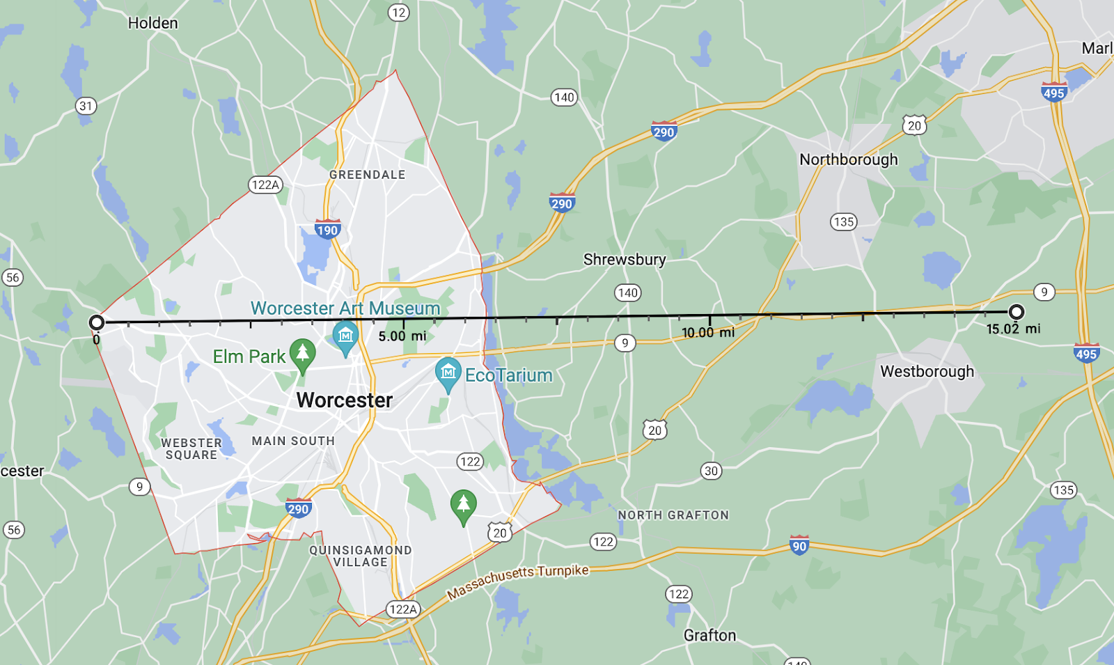
Having attempted to reproduce where I got this scale it seems like I copied and pasted the ruler from whatever real-world map I used to get the profile of the coastline to build my old map off of. On that old map and scale, Rhiassa measures a little less than 15 miles across at its widest east-west measurement. I superimposed the scale over where Rhiassa was to get that measurement.


To help improve understanding, 15 miles is roughly the distance between the west edge of Worcester and 495. So far, to me, that checks out. I've always assumed that Rhiassa, a smaller nation compared to many, would be around this size.


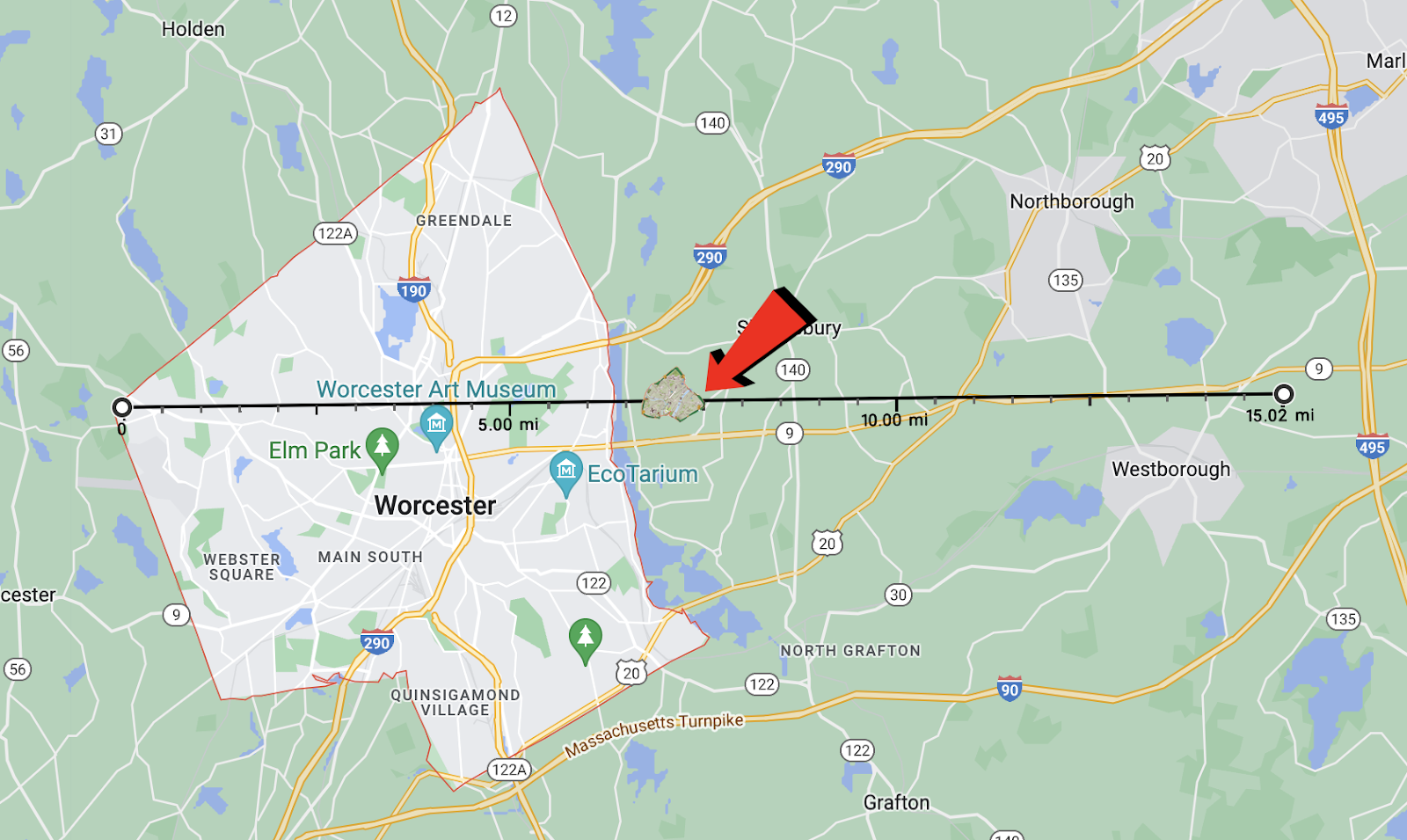
Again, to further add information to my own exploration of Rhiassa, Steve Johnson (Rhiassa's founder) always maintained that the capital city, Cold Springs, was meant to be a somewhat typical walled medieval city. I decided to compare it to the size of York, England’s medieval walls, since that’s a very famous example. I found a good-enough map showing those.


The scale on the bottom of that map goes to 1000 feet, so the overall width of the city at its widest point is just about 4/5 of a mile. If I was to represent that on the Worcester map it would look like this:


Every two graduations on that ruler is one mile, so that city size there is more or less to scale.


Comparing that to Rhiassa on the current map:


Rhiassa is one of the smaller nations on the map (this exercise only includes Rhiassa proper and not the added provinces of Periden and Lionsmark), so you can extrapolate from there how much larger the other, larger, nations would be on this 1:1 scale. So to me all of that pretty much checks out and the 1:1 scale that I've always internalized seems consistent with how the map is read.


There is also an argument for officially deviating from that 1:1 scale to expand to something bigger. Here to make that argument in 1500 words or less is Pat Bobell:


-----------------------------

A Scale for Our Pastime

I recognize that many people might not care about making the Realms world coherent within the medieval fantasy context. I'll warn you upfront that my whole agenda here is to argue that setting the Realms map's scale to match New England's IRL geography is ridiculous, even accounting for plenty of "iT's fAnTaSy" handwaving. Instead, we should use a larger scale to match the visions of the world we have collectively built through our decades of events, stories, and imaginings. To be clear, I think it's extremely cool that the Realms map roughly matches the geography of New England. The first time someone pointed that out to newbie-from-the-midwest me, it blew my mind. I want to keep that just the way it is. I don't think things should move around at all. I just want to talk about the distances between them. Since before I started playing in 2010, the Realms map we've considered "official" didn't list a scale with which to measure distances between our cities or along our borders. It's not something that ever comes up unless we feel like digging into the details of how long it takes to travel somewhere to add flavor to roleplaying conversation. Or if we wonder how many people live in our nations, or cities, or towns and might be affected by some new threat. Or how large our nations' armies are to fight that threat. Because I like details and figuring things out, and because I view the Realms as being somewhat larger than life (again, medieval fantasy), I was never under the impression that the Realms map distances matched IRL map distances. If we were operating at that scale, the capital city of Rhiassa would have a population three quarters the size of my rural-Illinois high school student body. (Cold Springs would house roughly 870 people, based on my overly-generous estimate.) "But Pat," you might masochistically or indulgently enquire, "how did you arrive at that weirdly specific rough estimate?" The short answer is "I google until I find useful info that seems relevant and decently informed, and extrapolate from that." The next paragraph is the longer answer, with links. Feel free to skip it if you don't care about such details. First, I overlaid a slightly-transparent screenshot of Jason Rosa's new Realms map on a Google Maps screenshot of New England in Inkscape, matching the size and position of Teng Hua up through Rathkeale up with the size and position of the Cape. Next, I pulled ruler lines to the edges of the "20 mile" scale marker on the Google Maps image, and used those lines' coordinates in the program to calculate a conversion ratio between pixels in the image and distance on the 1:1 scale map. After pulling grid lines over to approximate Rhiassa's area as a rectangle (eyeballing the little piece in the southwest fitting into the gaps along the northern border and southeast), I used those lines' positions and the conversion ratio to calculate an approximate land area for Rhiassa as a rectangle. (8.62 miles north to south, 16.83 miles east to west, giving them 145 square miles of area.) Generously assuming a population density of 120 people per square mile, that gives us 17,400 Rhiassans. That 120/sq. mile figure comes from this source, which offers adjustments to one of the most common sources used for medieval fantasy worldbuilding, found here. The revising source pegs 1450s-1500s Belgium at 110-127 people per square mile, one of the highest medieval population densities and according to them, the only European country to go above 100/sq. mile. While a range around 60-80/sq. mile would be more historically realistic, I use 120/sq. mile, the rough peak of historical medieval population density, as a baseline for areas in the Realms that are almost entirely farmable. My reasoning is that this adjustment should account for magic and other "unrealistic" perks of living in our semi-idealized world. From here, we're admittedly on shakier territory as I make some significant adjustments to the methodology offered in "Notes on Medieval Population Geography" to account for the Realms' access to magic and accelerated technological development. The author estimates roughly 5% of the medieval European population lived in cities of population 10,000 or higher, 4.4% in towns of 5,000-10,000 people, 3.5% in villages of 1,000-5,000, 3.1% in hamlets of 100-1,000 people, and the remaining 84% in communities of under 100 people. However, those percentages are for all of 1300s Europe. If we gave Rhiassa at 1:1 IRL scale a city of 10,000 people, that'd be 57% of the entire nation's population in one spot. Technically possible with a lot of magic, but also absurd enough to be beyond reasonable suspension of disbelief. So to adjust these estimates for populations too small for one or more settlements within a size category, I make a settlement with the corresponding percentage of the population. Thus, the largest town in Rhiassa would be 5% of its total population, or 870 people. Of course, a lot of this estimating can be shifted around a little to make things feel better, but we have to start somewhere. So, that brings us back to the capital of Rhiassa. I asked Jason Rosa what Cold Springs looked like in his imagination. He suggested medieval York or Cearcsiconne. I'd never heard of Cearcsiconne before and couldn't find useful numbers for it, but the York Museums Trust estimates that York's pre-Black Death population was around 15,000 people, and after the Black Death it could have dropped to around 10,000 people. Both are obviously drastically different from the 870 people I mentioned before, and this is why: If Rhiassa's total population sat at 17,400 and their capital city held 10k-15k people, that doesn't leave many farmers or other folk to work the other 99% of the countryside. If we're going to be using all the land as a way to estimate how many people there are, we need to be distributing people across that land. The numbers for Chimeron at a 1:1 scale with New England are similar. Chimeron City, the biggest monument to civilization, magic, and civic ego in the game, would have a population of 2,850 people. That's fewer people than modern-day Berlin, MA, the town that Camelot Practice is in that's almost entirely woods and fields and one big pond. Chim City would have barely enough people for a mid-sized village. It just doesn't work with the genre of epic fantasy that we as players and marshals have written for ourselves and each other So here's my suggestion: the scale of our Realms map relative to New England should be 2:1. This bumps Rhiassa's capital city up to a respectable 3500 people and Chimeron City to 14,700*. Those are still a bit smaller than I think most of us would envision if we put some thought into the matter, but anyone who wants to define this stuff for their own lands can adjust percentages and population densities so suit their needs. I'm certainly not telling anyone how to envision their own lands and populations. I just think that a default assumption of matching New England's scale is out of whack with what we already have in our minds, and picking a map scale closer to the scale of our stories will help those of us who do enjoy this kind of worldbuilding and detail to tell coherent stories together. If you read all this, thank you for taking the time. I started work on tracking Chimeron's demographics and population distribution back in 2013 and as you can tell, I both enjoy it and have Opinions. :) If you'd like to get into the weeds on any of this stuff regarding your own lands, or have questions about what I do with Chimeron, feel free to bring it up in person or to DM me on Discord! *The math I'm doing for Chimeronian populations is more complicated than simply multiplying by 4 (which works for my estimate for Rhiassa), because I'm also modeling Chimeron's recovery since the Bedlam War and reclamation of land that was left decultivated in Bedlam's wake. Having a larger population to work with earlier in the process means more land gets reclaimed sooner, which enables quicker/compounding population growth as new infrastructure is built.


-----------------------------


So there's a lot of math to convince you that a 2:1 scale makes more sense historically than a 1:1 scale.


I said from the beginning that I had always meant this to be a community project, so I'm not comfortable unilaterally making any kind of decision about what the scale is regardless of my personal opinion on the situation. The way I see it, the obvious options are 1:1, 2:1, or leave off the scale entirely and let people pretend whatever they want to pretend regardless of mathematical acuity. I extend all of those to you as options and welcome your discussion.


Tuesday, March 15, 2022

Aeston's Cartography Corner Part 5 - Filling Out, Filling In

Hi everyone, it's been a while. I don't want you think I've been idle, however, since you've last heard from me. In today's map update you'll see the following nations have been added (in this order) Sharangil, Teng Hua, Hedenkries, Rathkeale, Folkestone, Grimloch, Neden, Blackwood (which includes Blackwood North and Blackwood West), Northern Alliance, and Stonewood. 

You know, I was afraid I was going to have to defend myself for how long it took me to do an official update but now that I look at that list, I think I can just let the results speak for themselves. Here, as always, is a link to what's online so far: https://www.realmsnet.net/maps


It's been a productive six weeks or so since I last published. I'm proud of the fact that I got so many nations represented in a lot of detail, and I am deeply appreciative of the members of those nations who took the time to work with me to put everything on the map.

I'd be lying, however, if I didn't tell you that the first place my eyes go to is all the empty space and the amount of work I have yet to do to bring this project to completion. I can't promise it will be something I can quickly do. What you see above is the result of, conservatively, about fifteen hours of work a week just working in CorelDraw, not counting the time having conversations with nation leaders and getting feedback on drafts. Miles to go before I sleep.

So based on the time it's taken so far and the reasonable prediction that as the weather warms up there will be less time to sit in front of a computer, I'd predict it's going to take the lion's share of 2022 to finish this project. But I'll just keep plugging away at it and showing you the progress periodically.

Thank you for all of you continued support.

In service,
Jason "Aeston" Rosa


Friday, January 28, 2022

Aeston's Cartography Corner Part 4 - Brick by Brick

Hello everyone. I have only a few things to share today and one question I would like to pose for discussion. First of all, the online map has been updated again. After Leviathan was over I got back to work on adding nations that I could get complete information on. Here, again, is the link: https://www.realmsnet.net/maps

Banecroft, Eagle's Rook, and Voraniss were relatively easy for me to add since I had made versions of all of them for the O'er the Lands of the Realms series from a couple of years ago. Blackavar was something I had never worked on before but thanks to the Knights of the Sable Dragon I was able to get all the information I needed to add it in. So please take a look through the link above.

Again, I plan on getting to everyone, eventually. If you're a nation leader and I haven't reached out to you yet, please be patient. This is slow work but ultimately everyone will be included.

Also I've added some map symbols since the last time I made a post about them. Most of these were suggestions that I received through the #cartography channel on the Realms discord server. If you haven't joined the server to it, I suggest you do so. Lots of good discussion happens there every day. Invite link: https://discord.gg/ZSAKSQwP


Portals are a normal enough occurrence around here that a symbol for them is appropriate. Natural landmarks cover any kinds of environmental features such as special forests, mountain passes, caves... anything that warrants having a name. And a port symbol will be added adjacent to any population center that has a considerable shipping industry or something of the sort.

One thing you might notice is currently missing from the map are historical ruins; the traditional symbol we've used to represent a group that isn't around anymore and that had space on the map. I haven't gone in and added those yet though it is one of the things on my short-list of tasks to get to. Historical landmarks will end up being on their own layer that can be turned on and off. I'm considering using a new symbol for them, however. Right now there are lots of plot-ruins on the map and I think something to differentiate them from historical ruins is appropriate.


Finally the question I want to ask the community to discuss is elevation.

I set up topographical layers on the map as I was building it. I did this to try to represent the mountain ranges that historically have been on the map and also just trying to be generally geologically accurate for how land gradually rises above sea level with respect to the location of the ocean and the large inlets all over the map. But, I never really committed to an exact numeric scale.

For reference, the colors of the topography from lowest to highest on the map look like this: 


Overall, 14 different hight ranges starting at immediately above sea level on the left to the height of the highest mountains on the right.

For further reference, note that the hight of the mountains in the middle area of the Realms hang out around the middle of the scale, like this view of Chimeron and surrounding areas:


And the more extreme edges of the map have the taller mountains, like the Saurabian and Aspis Nor mountain ranges pictured below.


So it's really kind of up to us to decide what scale we are using and how much of an elevation difference there should be between each color level.

Just hitting on some basic facts, Mount Washington is 6,288′ in elevation so if we want to stick with New England geography as our guiding standard then we could have the scale top out around there. If we want to go more epic in scale, the tallest peaks in the Rocky Mountains are all over 14,000' in elevation.

So I leave that to you as a point of discussion. How tall is the right amount of tall for our mountains? What should the different colors of the scale represent. Please comment on Facebook, in the discord #cartography channel, or even just send me a PM to let me know what you think.

Thank you for your continued engagement with this project. It is a lot of fun to put together and I have enjoyed the conversations I've had with nation leaders as we've designed their areas.

In service,
Jason "Aeston" Rosa


Tuesday, January 4, 2022

Aeston's Cartography Corner Part 3 - Zoom Zoom Zoom

TLDR: The map is updated. The controls are in a menu on the bottom right of the page. Zoom way in on the three countries that currently exist on it to see the magic. Here's the link. https://www.realmsnet.net/maps. Also what should we do about historic groups and the areas of the map that they take up? Discussion question below.

-------

Hello, everyone. Welcome back to my verbose pontificating about the Realms Map. I do have some progress to show off today, some explanation I'd like to give, and a pretty big discussion question I'd like to pose. Let's go in that order.

So first, here again, is a link to the latest version of the Map. Reminder, this is still all a work in progress, and things are still subject to change. One big thing you should be aware of is that accessing the menu requires clicking on the gear icon in the bottom right corner of the browser window. https://www.realmsnet.net/maps

As you can see, Rhiassa, Ashenmark, and Chimeron are currently on the map. I decided to start close to home as I experiment with what can be done and how to do it. Initially you can't see much detail, just the outer border of each nation and the name. But zooming will reveal a lot more!

There are basically three 'levels' of zoom detail built into the map. The first, as you can see, is just as I described above. Borders and Labels.

The second level of zoom triggers at 800%. Once there the thick borders shift into thinner borders and you can see in Rhiassa and Chimeron how that is also used to denote specific sub-nations or provinces in the overall nation. Also at the middle zoom levels population centers the size of cities become visible as do roads that are considered 'major roads'. Labels for countries and cities appear as well.

At the third and final level of zoom all detail becomes available. Population centers of any size as large as a village, other landmarks, minor roads, labels on lakes and rivers. This is the ultimate version of what I want to accomplish with this map, giving every group the ability to really lay out a detailed schematic for what is where in their country.

Like before, in the menu, there are check-boxes to turn different layers on and off. If the roads or the forests are getting in the way of the viewing experience you want, you can just turn them off. It's programmed so that even as you switch zoom levels a layer won't reveal itself if you have already turned it off. Thank you again to Ian Pushee for all of the work on the programming end to make these functions possible.


Okay now on to some explanation. Those of you who have worked with me to make some of the detailed maps in Inkarnate are familiar with some of this, but I feel like this is important information to get through.

Borders in a medieval setting are inherently unlike those made in modern times. I won't go so far as to say that it would never happen, but generally it's not the case that you'd go into the very middle of an open field, plunk down a wall, and say thats where your border is. Instead, borders were usually dictated by the landscape. Lakes and rivers served as markers, even things like the edges of forests, mountain ranges, or valleys. This is not a universal law or anything, but in my previous map making projects that I worked on for the View's "O'er the Lands of the Realms" series I usually tried to add in some sort of landscape-driven justification for the borders that all of our nations already have.

To make things even more complicated than that, there are some "rules" about rivers from just a geological point of view. Obviously they usually start at a high elevation, always run downhill, cardinal direction does not matter to them, and the great, great majority of the time a single river does not split and rejoin itself later down in it's path. You'll see as you look around the rivers and lakes that I have already added that they follow these rules to the best of my ability.

So designing a nation on the map is a slow process that involves a lot of steps and revision. The original borders from the historic version of the map need to be honored, landmarks need to be added or manipulated in order to make these borders 'realistic', and then as cities, roads, and landmarks get added these need to further change the complexion of how everything is arranged.

It probably took me about 20 hours to do the three nations that are already on the map. Some nations will come together faster and some slower, but overall it's going to take a lot of time to build this all out. So I'm going to ask for your patience as I get to everyone. When I know I'm ready to do your nation I plan on reaching out to the leader of the group so we can design it together.


Finally, the question that I want to put out for discussion this week. It is something that Janna eluded to in a discord discussion on the #cartography channel and I think is a very important thing for us to decide going forward, and that's what to do about historic nations, their presence on the map, and the borders for their countries.

As many of you know, on the previous versions of the map, when a group was no longer around and no new group specifically took up their mantle, that area of the map would be changed to a ruins icon that usually took the place of a main city of that group. If that group had a border it was removed. There was no set deadline on when a nation "expired", it was mostly up to the author of the map and a gut feeling.

So essentially there were three "states of being" for a group.

1. Active group with a border around their lands

2. Active group that was just a single population center (city) with no border

3. An inactive group that was represented by one or more ruins and had no border

(it's worth pointing out that some ruins on the previous map are not defunct groups but rather plot-driven points of interest represented as ruins).

While we do need a way to denote historic groups on this new map, we do not have to be locked in to the same process and only those three "states of being" from before. I think it is important to represent history on the map and I think there are multiple ways of doing it. I'm going to make some suggestions that come to mind for additional ways to honor history.

Case A. A group that isn't 'active' anymore but isn't completely removed from the current Realms. For example, Vinehaeven. No one really plays the game as Vinehaeven members anymore but there are still people 'in charge' of Vinehaeven that are around and play frequently. It is also important in that many players because it is the home of the Oaken Guard which many current players originated from.

In an example like Vinehaeven, even though the group is not active, I think what makes the most sense is to remove it's border and leave it on the map as a population center (and Fort Oakenbrook as well). So groups that are still culturally important to the game can remain on the map as cities, towns, etc, but they have lost their "influence" enough to actively control land inside their border.

Case B. A group that isn't 'active' anymore but might not be able to be properly represented by a single ruins icon. For example, The Southern Wastes. Again, some members of the Southern Wastes are still somewhat around but certainly not to the extent that the players 'control' a large area of the map.

In an example like The Southern Wastes, I think what makes sense is to have a label describing a region on the map. The 'Connecticut' area will always be The Southern Wastes to the Realms, it's such a big part of the history of the game, so I'd prefer to put a regional label over the area the way a modern map would label something like the Sahara Desert. It doesn't have a political boundary but it's clearly a big part of the makeup of the map of Africa.

Case C. Cleaning up plot areas. A lot of times there are important reasons for a plot-driven area to take up a section of the map. But when plots officially end or when they just fade out into history having never actually wrapped up, I'm not sure it makes sense to lock away those areas of the map forever. I also think that this is a very case-by-case consideration depending on how much that plot culturally influenced the Realms and how much of an effect it has on IC interactions today. 

For example, New Illinar takes up a large portion of the map near Voraniss. That plot has been pretty much complete for over a decade. I think it makes sense to have Illinar still on the map, it had a dramatic impact on the Realms for an extended period of time and is a part of our shared history. I think it can represent that by being a fraction of the size that it already is, allowing it to exist, to continue to be used for plot elements that relate to it's history (there are still a few) but not take up so much room as to dominate the region.

Overall I would call upon plot runners of the past to take a look at the map and see if there is anything that could be or should be 'cleaned up'.

So those are my thoughts about some ways to deal with clearing up the map a bit, but these ideas are just suggestions as we come up with the best way to create this map together. I would love to hear any and all of your ideas as FB comments, discussion on the #cartography channel on discord, or via PM. Thank you, as always, for your support.

In service,

Jason "Aeston" Rosa


Tuesday, December 21, 2021

Aeston's Cartography Corner 2 - Long Road to Ruins

Hello everyone. I don't have anything new to show on the map itself, this week. I have been adding new things to it, it's just not far enough along to display the progress yet. Instead I'd like to take this opportunity to start a small discussion and solicit some feedback.

As an overarching thought that I'd like everyone to consider, I think it is important for us, as a community, to decide what the map is "for". Of course that answer will not be the same for everyone, it has certainly not been in the past. Some people have treated the map as a loose guide to where everything is while others have managed their corner of it with painstaking specificity. Some have used it as a method to display their in-game power with the size of their huge tracts of land, others barely care that their nation is represented on it. We're not a game that relies on a map the same way a TTRPG might, but the map does have a lot of capacity to enrich our world.

So my first question is just that: To you, what is the map for? What goals should we consider while we recreate it?

Now, a couple of questions that will more practically help me in my design and drawing of the map.

Lets talk about towns, ruins, and other landmarks

In the previous version of the map, population centers and ruins were designated with the following symbols:

So there were four available sizes of population centers and ruins which were mostly meant to mark historic Realms nations that no longer exist, though they were certainly used for other things as well.

I would like this version of the map to be a little more information-dense and give nation-owners a little more choice as they design where things are in their borders, so I propose an expanded set of symbols. This is what I whipped up after a little consideration:


Most of the descriptions on the symbols above are hopefully self- explanatory. I'll just add that the "important location" symbol is meant to be a catch-all for any landmark not already on the list - a lone tavern, an academy, etc.

I'm not wed to these particular symbols, it was only my first attempt. So for my second question I'd like feedback on people's opinions on these symbols. particularly if this is too much specificity or not enough, if there are important symbols that would be widely used that are missing and need to be included.

Lastly I'd like to bring up the issue of roads.

When Carrie made her original map she decided to add established roads and paths. This was something Doug "Remissil"Aucoin did not have on his version. This was Carrie's map key at the time.


When I inherited the map from her I continued that element of the map and Doug carried it over to his version of the map as well. The issue, however, is how much more complex the map has gotten over time. When Carrie made her first map there were only about 30 or so nations and they were pretty small, relatively.


Even during the later part of my tenure with the map, while things had certainly expanded since then, the information on the map was not so dense that the system of roads was out of control, though you can see it trending in that direction.


Doug made the map much more of a work of art than Carrie or I ever did, and in doing so added a lot of visual information to it. Forests, hills, mountains, and other map elements left very little negative space. 


The above three pictures illustrates how much more complicated the map has become as it has spanned three decades and has absorbed the community world-building from everyone across the Realms.

So, back to roads. The question I asked myself, and now to you, are: what are they really for? There's never been any kind of doubt that you can get from one location in the Realms to another. I don't think many people consult the highways on the Relams map when questing and say in their best Maine accent "Ya can't get thar from here." Is it worth adding roads to the new version of the map or will it just add clutter? Is it worth still specifying which roads are paved and which are dirt? My personal opinion is that they are vestigial and we can move on without them but this is a community project and I'm eager to hear your thoughts.

So the third and final question is: Roads, what do we do?

Thank you for taking the time to read this article and thank you in advance for any feedback you want to give over the Facebook comments, through PM, or over the Realms Discord #cartography channel. 

In service,
Jason "Aeston" Rosa


Tuesday, December 14, 2021

Aeston’s Cartography Corner

 TLDR: I’m launching a new Realms Map project. Instead of this being a project that’s entirely mine I would like it to involve a lot of community consensus and I would like to communicate progress and solicit feedback through View articles. I know many of you have updates to make to the map. I’m not quite ready to start accepting all of your information but I will in the near future. I will also be publishing guidelines that we create for map addition in order to make the project most sustainable. Here’s the link to see it so far: https://www.realmsnet.net/maps

Hello Realms,

It’s been almost two decades since I last attempted to make a map of the entire Realms. Since some of the people reading this are probably unaware, I was the manager of the Realms map for about five years in the early 2000s after inheriting the project from Carrie Dolph and before passing the project on to the very talented Douglas Fisher who is the one who really transformed it to the version that exists today. 

I’ve learned a bit since those early days about how to manage projects sustainably, about digital art and graphic design, and about how to balance many expectations and opinions to create something cohesive and amenable to many parties, and so I’d like to beg all of your indulgences and ask you to help me make this map so it’s less on an individual effort and more a result of the many voices of the Realms working together to create something valuable for our community.

This will be a project done in many steps and over the course of a few months. I don’t think it makes sense to hurry when we are trying to make something that endures. It’s also important to me that we build it in such a way that makes it easy to understand and edit over the long term. The map is something that needs regular updates and I expect that other people will inherit the map management from me one day and I want them to be able to continue to work on it seamlessly based on the foundation we make.

First, for those interested, please allow me to explain a little bit about how I am building the map and the techniques that I am using.

I am creating the new map file on a 27” iMac using CorelDraw 8. I know the Corel suite of programs is significantly less popular than Adobe but I’ve been using it since high school, so it’s what I know. The map is being created and displayed using vector graphics. A little bit of a technical explanation, the benefit of vector graphics over raster graphics (png, jpg, etc) is that it will not become pixelated at higher levels of zoom and allow for very fine detail. The overall document is sized for printing on an 11”x17” (tabloid) sized paper. The image is being created in layers depending on terrain type and the individual vector objects are named for their type and location on the map. Hopefully this system will allow us to stay organized and allow for easier future editing. Here is a screenshot of how I have things set up for those who are interested.

Ian Pushee has graciously agreed to host the new map on RealmsNET and has created a page that will allow the file to display as an SVG (scalable vector graphic) along with in-browser zooming and panning controls. Even more impressive, Ian has created a way that will allow layers of the map to be turned on and off in-browser, something you’ll be able to experience as the elevation, forests, and mountains can be toggled in the current version. As more detail gets added to the map this ability to zoom in will allow for very specific detailing to be visible at high magnification levels through the use of layers that only appear when the zoom level is high. Essentially, I’d like it to feel sort of like Google Maps. The more you zoom in the more fine detail you can see about each nation. Thank you, Ian, for your considerable help with making this project feasible.

Anyway, I’m sure you’re eager to see it. Here’s the link to the page. https://www.realmsnet.net/maps

For this initial unveiling of my work and the announcement of the project, I have spent the last few weeks creating the basic landform of the Realms. You’ll notice that my art style differs somewhat from previous versions of the map. What I’m creating is more of a technical drawing than it is a painting. I’m not really an artist of any merit, I’m a cartographer. I’m trying to create a definitive guide to where things are in the Realms and how our world is put together. The emphasis is on accuracy and less on aesthetics though of course I still have the goal of making it look nice.

The topography of the land is indicated through different green and grey colors and lakes, rivers, and forests are represented as well. A map key to make all of that more clear is forthcoming.

I’ve tried to stay very true to the last iteration of the map even as I change the overall art style. In some places where I have made subtle changes it is because I have already had considerable conversations with owners of those lands though the View’s O’er The Lands of the Realms series from a couple of years ago.

I know many of you are eager to have your nations added to the map, especially those of you who have had changes to your lands since the last time the previous version of the map was updated. I’m going to ask for your patience before we dive right into that part. Because I’d like to build this with community input I’m going to be getting feedback on one component of the map at a time and making adjustments as we go.

Please enjoy looking over the work I have done so far. It’s only the tip of the iceberg but I’m confident we’ll be able to make something awesome for our community. I’ll happily accept feedback by way of private message, responses to the View post on facebook, or over Realms discord and if you notice that something looks wrong in the topography, especially if it's in an area of the map you know you “own” please let me know so that I can address it.

In service,

Jason “Aeston” Rosa


Thursday, July 23, 2020

O'er The Lands of the Realms: Rathkeale

by Jason "Aeston" Rosa


Description by Brendan "Hayden" Lam

Welcome to The Empire of Rathkeale also known as New Rathkeale, the last remnants of a history bygone past. Some quick rules before we tour the wondrous lands that have a deep rooted history inside the timeline that is The Realms!

One
Rathkeale is a home to those who have none! If you need a place to stay and you don’t rub Emperor Hayden the wrong way then your welcome as long as you don't break anything. And remember to wait half an hour before taking a dip or the sea monsters will get indigestion.

Two
Be understanding of the culture, what seems might be conceived as “EVIL!!!!” to you could simply be someone trying to raise a family…

Three
Freedom of Religion! Don’t be a bigot! Everybody and thing is welcomed! Let’s all have some fun and be civilized in a barbaric kinda fashion!

Four
Have fun at the cost of your own safety… no one is responsible for you unless you got homies so if you walk through a portal it's not our fault if you're trapped forever.

Five
The fauna and foliage are all hostile, Emperor Hayden does indeed have a few screws loose and Necromancy is totally not an evil practice! Also bug Lord Elric if you have any problems. Why you ask? Why not he’s the right hand of the Emperor. What's the point of being a leader if you can’t delegate issues to your trusted aid.

There are other rules and laws but these 5 kinda encompass what Hayden’s vision of Rathkeale should be after taking management of it from Emperor Artex Bluebane; a wild place to be but a place welcoming to many if not all.

To start our journey we start on the peninsula and the city that was built on it, Rock Wood! The harbor city of Rockwood is the main trade harbor for Rathkeale; it is here that most of our exchange and commerce among the Realms occur. A quaint place to get a feel for the mood of Rathkeale as it is filled with Taverns, Bars, Brothels, and more. If you're looking for some fine dining visit the Bone’s BBQ Bonanza! Where the finest blood wine in all the Realms is served. Looking for some armor and wears…? Cassin’s Weapons and the Rathkeale Forge are the nicest stores you’ll find in the far reaches of the Empire some might say the only stores you find in the Empire! And if you're injured or beaten take Misty’s Mist Apothecary to get those wounds taken care off. If you're sick and tired of the hustle and bustle of Rock Wood catch a dingy and if you survive the monster infested waters you can take a quick trip over to Brewerton.

Ahh Brewerton an entire settlement dedicated to the brewing of Blood Wine and fabrication of Kraken Ink! You can take a tour, a sip and maybe even a dip at your own risk of course and feel the culture or couture of the Rathkeale lifestyle. From here you can island hop to some deserted island and meet the local indigenous species. After dancing with the skeletons or rocking out with the banshees you'll make your way to the sword and shield of the empire Videssos and Crucible!

Videssos and Crucible are where the armies and manpower of Rathkeale come from. Here we train soldiers and raise armies. No better place than to raise a family as well strong and eternal bonds! Our captain of the Imperial undead legion Sven Svenson will tell you it's a piece of hel-Heaven on earth! Some say when you come here you never want to leave. It is like a piece of a mythical realm set on our wondrous land. A place where mystical will happen and open your eyes to an entirely new view on the world. But if you resist the temptation of its wondrous training regiments and health care plan then you’ll probably take a trip to Donovale.

Donovale what a small little port city it is. Nice and quaint generally quiet as a ghost town and serves as a tranquil resting ground for weary travelers. This little port city is where products and goods are shipped out to and then transferred via sea vessel to Rock Wood. People come to Donovale to take in the mainland of Rathkeale to see the haunted forests, the tombs where great heroes and the Dishonored are buried; apparently there are tombs and catacombs all over Rathkeale filled with who knows what. It also serves as an eternal resting ground for those waiting to travel to the heart of the Empire. The Castle of Rathkeale where the Emperor Rests till he is called upon again.

The Castle of Rathkeale is a large city sized structure where all major celebrations and experimentations happen. It is here Hayden found his home and his greatest creations. There is not much to say about the castle, it is like any other. It sits upon a large burial ground where warriors and creatures alike have died. It's catacombs and cellars go deep into the reaches of the earth. The security is consistent with a great number of Undead both hostile and friendly; and the Knights of the Silver Chalice, as the Castle also serves as a headquarters of sorts. And to top it all off it is home to an intelligent Dracolich that helps maintain the island and has a hand in the wonderous technological advances in the Empire’s Labs.

That consists of the mainland but there's still more to come! First is the island of Revenant and there's not much to say about it other than what its name represents. Venture here at your own risk. There is a small settlement that remains partially inhabitant on it; It is named Roanoke. It is here that we leave that which we do not want to deal with at the time. There are rumors that the island serves as a Demonic Poison Pot but hey rumors are just rumors right?

Next is the island of Skye, for the most part this island is uninhabited only a large tower was constructed on it. Visit if you wish but we hold no responsibility for your safety if you do. A quick piece of advice, it is said a silvery creature inhabits that island. It tends to not bother anyone but you can never be too careful. Stories say the creature is nothing but a myth used to dissuade visitors; others say it is a creature that will whisk you away to another land familiar yet not...

Finally our journey comes to an end on the island of Vangaurd. Vanguard for the most part remains as a large untouched land of nature. The inhabitants of the Empire visit Vanguard to pay respects and to get away from the hustle and bustle of the world. On this island a small settlement was constructed. The City of Oden there isn't much to say about this city. There's a small church that was constructed at its center for the church of Chaos, and the entire settlement serves as a military outpost. Surprisingly some people find this land to be a great place to settle down and at times we sell small plots of lands to them for the right price. The island itself has some unique things hidden about it, but with all that was said it is a story for another time...

It has been a pleasure to talk about the wondrous land that I call my home and I hope that those of you who are out there will visit someday. Whether it be a good natured visit or one of war The Empire of Rathkeale will always open its doors!

Tuesday, November 26, 2019

O'er The Lands of the Realms: Chimeron (Part 1)

by Jason "Aeston" Rosa


Description by Pat "Saka" Bobell

Introduction


Several nations are (and others once were) a part of the Kingdom of Chimeron, but at the heart of them all is the land of Chimeron proper. A storied place of magic and bounty, Chimeron is thoroughly intertwined with Faerie, and was lost to the Mysts until nearly thirty years ago as I write this. In the year 991, Chimeron proper reappeared to the Realms and was reestablished by Queen "Meg" Marguerite. Much has changed in the lands of Chimeron proper and its people through the past twenty-eight years of activity. Countless threats emerged and were vanquished. Nations rose to prominence and fell away. In the year 1002, Queen Meg went under the Hill to ensure Chimeron's continued survival. King Pyr then reigned until he took his place as Oracle of the Deep Fae in 1010. In the time since, the lands have continued to flourish under the rule of King Alexander Cecil.

As with many parts of the Realms, our land was naught but mountains, lakes, rivers, and rolling green hills and plains following the scourge of Bedlam, but Chimeronians are nothing if not industrious and proud of their home. In the years since the Infinite Dark's defeat, we have rebuilt and continued to develop our lands, taking great care to respect our history, our connection to Fae, and our role as a hub of trade and civilization within the greater Realms.

I have spent many a night flying above Chimeron, and more days than I care to count traveling to inspect Militia garrisons. I expect I know the lay of the land as well as anyone, though my grasp of detailed history is somewhat lacking. Nevertheless, I find myself writing a brief summary of landmarks within Chimeron proper to accompany Lord Aeston's fine cartography. The various villages and towns and smaller geographic features in Chimeron are a multitude, and both Lord Aeston and I thought it prudent to omit most from the map and this summary in favor of usability. Friends of Chimeron who wish to familiarize themselves with such minutiae are welcome to peruse (most of) my auxillary maps and ledgers at their leisure. For those of you who simply desire to travel or conduct business within Chimeron and know what is what while you are here, this map and information should be a great plenty. Should you discover any inaccuracies, please let me know.

Sir Sakariasvafnir Keeneye of Clan Rua Thar Cinn, Warlord of Chimeron
Monday the 25th Day of November of Year 1019


Cities


Chimeron

If the heart of the Kingdom is Chimeron proper, the heart of Chimeron proper is Chimeron City. (It is Chimeron all the way down.) A bit southward from the end of the Whitestone Mountain range, and near the western bank of the Rowan, "Chim City" is home to Chimeron Castle, the notorious Bar & Wench and the Scarlet Torch establishments, the main Militia Barracks, and many of Chimeron's active adventurers. Court is held daily in the throne room, unless it is not. It really depends on what else is going on. While Chimeron City has many fine inns, it is recommended that travelers make advance arrangements for their stay given the large volume of visitors and traders in the city throughout the year. The various marketplaces each have something special to offer, though the finest goods are typically found in the shops along High Street. Hardly a week goes by without a new play, concert, artisan exhibition, or some such thing taking the city by storm, so there should be plenty to enjoy if you have some time during a visit.

Norfork

If you take the northern road from Chimeron City and do not stray from the densely-wooded path, you will find yourself in Norfork. Situated at the intersections of roads from Banecroft, Qua Taereth Nunna, and Chim City, this is a city that knows what it is about. There is little arable land, so the main focus here is catering to trade, travel, and keeping livestock. There is some excellent metalwork being done here, thanks to all the mining towns skirting the Whitestone Mountains and more timber than the lumberjacks know what to do with.

Duskwatch

I do not have much to say about Duskwatch. It is deep within the wildest of our forests, and with all the soft spots a consistent path through the trees is not really an option. The location on this map is only approximate - I gave Lord Aeston my best guess from flying overhead. My experience with the people there has been positive, despite their seclusion. All very even-keeled, hardworking folk. Most seem to be experts in their respective trades.

Brighton

Brighton was a town which went by a different name before Bedlam struck, but it was refounded and grew much larger than before as a new home to a sizeable Militia garrison near our border with Darkvale. Many of Chimeron's finest come up through the ranks in Brighton, and the Rangers there have been doing excellent work scouting for the always-impending conflict. Travel north from Brighton is highly discouraged. Those looking to reach Pax Tharkus should detour southward to Fort Griffindor, then west and north through Eagle's Rook and Blackavar. (A rudimentary road between Blackavar and Wren is in progress.)

Fort Griffindor

Following the Faerill River south from Brighton, Fort Griffindor is the home of - you guessed it - Griffindor! Their walls are 4 miles to a side, each perfectly facing in one of the cardinal directions. While it has historically been the target of much destruction, Fort Griffindor is only second to Chimeron City in strength and size in all of Chimeron proper. (This pairs nicely with Griffindor's tenets to to defend the innocent, provide for those who have no lord of their own, and to defend Chimeron and the Realms.) With a lake, river access within the Fort, and east-west trade flowing with Eagle's Rook, business is booming for those who call Griffindor home. If you have not yet experienced it, I highly recommend a walk along the river bank near the north wall early in the morning. That stretch of river is less developed and incredibly peaceful, and watching the sun rise over the far eastern wall is a treat.

Pinedale

Our other primary trade hub with Eagle's Rook is Pinedale, aptly named for the coniferous forest it was mostly built from. Getting from Pinedale to other larger cities within Chimeron involves either circuitous boat routes or slow overland travel along smaller roads to Fort Griffindor. As a result, most economic activity results from local logging, fishing, agriculture, and trade between Eagle's Rook and Rhiassa. I am told the Pinedale Distillery puts out top-notch...some sort of alcohol. Not really my area of expertise.

New Fleetwood & Eastfleet

Hopping all the way over to where the Mudbrook River flows into the Rowan, New Fleetwood and Eastfleet are the bustling homes to Chimeron's merchant marine. While New Fleetwood was established right where Fleetwood stood pre-Bedlam, Eastfleet sprang up in an effort to more quickly meet the needs of river traders supplying all the reconstruction efforts. In the years since, the cities have regulated trade such that ships exporting from Chimeron all pass through New Fleetwood, while those delivering goods within Chimeron must register their cargo in Eastfleet. (They claim this is because taking the traderoad north from Eastfleet is easier than sailing north against the current. I would hazard a guess that their trade officials spent too much time around folks from Ashenmark evangelizing bureaucratic processes and colorful charts.)

Willow Hearth

While this is a newly rebuilt city, there is a fair amount of old Chimeronian wealth here. The land east of the Whiteleaf River is so fertile this little corner of Chimeron proper grows fully thirty-four percent of our domestic produce. The architecture of the city is quite impressive, though I am glad I had the opportunity to see it before the reconstruction. Some of the noble families have magically aged their properties to try to recapture the ambiance of bygone Willow Hearth, but it is not quite the same.

Stoneroot

Last but certainly not least, we have Stoneroot. An unassuming name for a large city, but many of the folks who make this their home are anything but. It takes a certain type of character to live "in Chimeron's elbow," as some say. Some time ago a decent amount of trade bound for Paradise passed through, but since those lands were folded into Chimeron proper and mostly reclaimed by nature, the former trade hub has mostly become known for fortune hunters heading into the hills after cursed treasure and caravan guards for hire on the road up to Cawdyll. If you ask me, those stories are overblown and Stoneroot is mostly home to folk looking for the opportunities life in a Chimeronian city brings, but with a smaller price tag than the alternatives. There is, however, no denying that Stoneroot has a unique charm to it.

Other Landmarks


The Crown's Road

A marvel of modern magical masonry, The Crown's Road is forty feet wide and runs east-to-west all the way from Stoneroot, through Chimeron City and Fort Griffindor, to the northern bridge into Eagle's Rook. That entire length is seamless stone, curved just enough to ensure rainwater runs off to either side of the road. I consider myself fairly good with both magic and my hands, but I do not rightly know how this masterpiece was made.

Forests

You should probably stay on the path.
You may still end up in Fae.
You have been warned.

McKrye Pass

This is the most convenient mountain pass to get between Qua Taereth Nunna and most of Chimeron on one side, and Cawdyll, Blackwater, and Fairhaven on the other. Folks who have had too much ale might try to sell you on the notion that the McKrye chopped the pass out with an axe.

Mirror Lake

It does not make sense, but this large lake between Chimeron City and Fort Griffindor is almost always perfectly still. Even the surfaces of the fairly large, flowing rivers fail to show any visible trace of a current until you get about twenty feet away from the lake. Many around Chimeron call it "the Looking Glass of the Gods". For those of you who can fly, gliding over on a clear, starry night is a wondrous experience.

Waystones

Over the past two years, Captain Orion has led a project to have tall stone pylons placed roughly every half-mile along the major roads throughout Chimeron proper. Each pylon, or "waystone" as they have come to be called, is engraved with a unique number and shows the direction and distance to the nearest settlements from its position. At night or in inclement weather, the engravings are magically illuminated for legibility (and to serve as beacons if conditions are sufficiently poor).